BrownStone Chinooks is devoted to fostering the excellent health and wonderful temperament of Chinook dogs. Hard-working Chinooks excel in many activities such as agility, obedience, back yard play, hiking, dog powered sports, search and rescue, and as service dogs. The affectionate Chinook is an excellent family dog matching its activity level to that of its companions - be it strenuous exercise or snuggling on the couch.

Sunday, September 15, 2019

Crossing Baffin Bay - Day 4

Crossing Baffin Bay from Greenland to near the top of Baffin Island was pretty much just rolling along in a dark ocean. Our time was spent staggering about in ship passages; enjoying way too much food and; listening to presentations on "Birds of the Arctic: Adapt or Get Out"; "Humans in the Arctic: A Brief History"; "The Arctic: Nunavut's Place in the World" and: "What Happened to the Greenland Norse?" The archeologist giving the talk on the Inuit had to adapt (grab his coat and camera) and quickly get out when the announcement of "Whales!" came from the bridge.
Rare Peaked Whales never recorded at this latitude. Conor, our always gleeful, Welch, PhD whale biologist, naturalist and ecologist, was over the top excited at documenting the sighting.

 Our fist significant iceberg
 Sunset was at 2034.
 The coast of Baffin Island at sunset.
From our daily briefing: "Today we will be at sea, crossing Baffin Bay. This body of water lies between Greenland and Baffin Island, forming a largely impenetrable waterway between the north Atlantic and Arctic oceans due to its abundance of ice.
Baffin Bay has been inhabited for at least two and a half thousand years, primarily by the Dorset people, followed later by the Thule.
In 1585 British explorer John Davis was the first known European to enter the bay, thought it is entirely likely fishermen or whalers may have arrived earlier and not made it well known. William Baffin made five voyages to the arctic and reached Baffin Bay in 1616. During these voyages it was proven to Europeans that the north-west passage was not reachable through Hudson Bay".

Saturday, September 14, 2019

High Arctic Day 3 - Sisimuit

A good morning for breakfast on the aft-deck - Sandy's special place.
Sisimiut lies just north of the Arctic Circle and is the northernmost town in Greenland where the port remains free of ice in the winter, and at the same time, it is the southernmost town in Greenland where it is possible to drive a dogsled in winter and spring
Sisimiut means "the inhabitants at the foxholes". The town was founded in 1756 as a mission and trading station under the name Holsteinborg. However, the area has probably been a settlement site for more than 4,500 years.
I should have waited for the sun to move to take this picture.
The municipality of Sisimiut is Greenland's second largest municipality with 6,000 inhabit6ants living in the town itself along with the settlements of Kangerlussuaq, Safannguaq and Itilleq.
Fishing is the town't main industry.
We were given the option of a walk through the city with local guides and naturalists. A shorter city walk or a Photo walk with the Nat Geo Photo Team. The vivid colors of the community beckoned. The choice was a no-brainer. Our hike was not a "photography lesson" hike as I had anticipated. My first question: "what settings should I use to capture this scene?"  was answered with "wait until the sun moves." Our group was quick spread about the length and breath of Sisimuit much to the chagrin of our guides. Photographers are not ones to follow a set pace when the prefect shot is at stake.
Sisimuit Church
Built in 1775 the blue church is Greenlands oldest church.The portal is made from whale jaw bones. Inside were two displays: one of the God-fearing church and the other of shamanism. Each featured an interactive video answering questions about traditional beliefs.
Schoolbell
A much photographed house. We were almost run over as we stood in the middle of the road trying to get the best angle and avoid the laundry hanging just below the red deck board. After only one night onboard, the idea that we would have to dodge traffic already seemed foreign.
There are about 1,000 sled dogs in Sisimuit. Most are chained out in a communal dog yard. Guess what these two were doing 2 foot from the road side when we walked up. I actually had to explain to my fellow photographers why they were facing different directions.
Sleds were stacked everywhere.
According to Ehrlich in The Cold Haven: "Greenlandic dogs are descended from the first canine migrants who came to Greenland from Ellesmere Island. No other dogs are allowed into Greenland thus keeping the bloodlines pure. They pay attention only to the one who feeds them. Otherwise they are unconcerned with human affairs". Much to my joy, the Sisimuit dogs did respond to a universal canine howl I initiated.
Greenlandic sleds vary in size according to function and time of year. Sleds up to 18' long are used in spring to hunt narwhal when the sea ice is breaking up and for hauling large loads and crossing ice leads. Sleds for seal hunting and local and mountain travel are only 6 to 8 feet in length. Thule sleds were sometimes made of walrus bones with frozen peat runners and rolled hides or frozen fish as handles. A more modern sled on museum display (on the lower right) was the the only sled I saw the entire trip with runners and a bow bow. Greenlanders use a fan hitch system for their dogs and ride on or run beside their sleds.
This house with it's dog team was perched on top of the highest rock in town. I can not even imagine hooking up the team and flying down through town.
Kayak is an Inuit word. The local kayak club continues to make traditional skin covered kayaks and hold rolling competitions.
A local champion kayaker gave us a demonstration of numerous competitive methods of rolling a kayak.
The full paddle
Under the boat roll.
After doing about a dozen rolls in the frigid water, he was as exhausted as we were impressed.
What would a photo essay of the arctic be without pictures of Arctic cotton?
My desk is decorated with samples from previous arctic trips.
Early homes were built with sod and rock walls. Some still remain intact. 
Alas, full sim-cards in hand, it was back down the hill to the boat.
First we were challenged to the best photo of the canal.
Mine won.
A last look at Sisimuit as we floated out of port.
High Arctic Adventure Day 1-2

The high arctic, Baffin Bay in particular, has fascinated me forever and topped my bucket list. I started reading and collecting books on the area after my college internship in Nome. Since I have always been a dusty-boots, carry-your-home-on-your-back and create-your-own-experience adventurer, I never expected the luxury of a National Geographic Explorer ship would fulfill my dream. Now I can't imagine doing it any other way. What's not to like about traveling with an equally excited, great friend; endless plates of fancy food cooked from scratch; spending 3 weeks with 139 other like minded environmentalists; an amazing crew and; a team of international scientists and National Geographic photographers.
This trip was not licensed as a "cruise" but as an "expedition". The scientists were working along with guiding our adventures and giving presentations. The dive team produced videos, slides and sound recordings of the world beneath our ship. The daily agenda was dictated by ice and wildlife not a predestined course. Only two ports-of-call were scheduled. One we had to lower zodiacs to move an iceberg out of the way so we could dock.
The trip began with a long, slow, stop-and-go commute to PDX for a delayed, night flight to Reykjavik, Iceland. While flying somewhere over the pole, I was treated to about an hour of spectacular northern lights. I so wanted to wake others on the plane. Later I found out that the captain had videoed the show.
Iceland from the air.
Sandy and I had booked a trip to the Perlan Wonders of Iceland Exhibition but after 15 hours of car and airplane seats, we opted for the famed Blue Lagoon Geothermal Pool to hot soak our tired, cramped bodies along with people from all over the world - drinks and a volcanic ash facial were included. 
Blue Lagoon
Later that day it was off to Kangerlussuaq, Greenland, population 160. A seen-better-days bus gave a mighty effort to get us the mile and 1/2 from the airport to the fiord. After an old school bus loaded with cheering, fellow travelers passed us, we contemplated getting out and walking up the hill to give our bus a fighting chance to make it over the pass. Our slow commute was not wasted. The driver shared a wealth of knowledge about his town, country and wildlife along with his boast that he got to drive the school bus on the next trip.
Kangerlussauaq airport
Town of Kangerlussuaq located at the end of a magnificent 130 mile long fiord (photographed out well worn bus windows).
National Geographic Explorer awaiting us at the shallow Kangerlussuaq port
 Our ship was at anchor far out in the shallow bay necessitating our first zodiac ride. 
In the mean time, our luggage was loaded from the plane into a shipping container. The container was then transported the same 1 1/2 mile rutted, gravel road to the port where it was loaded by an antique crane onto a boat for transit to our ship.
Sandy and I race our luggage to the ship.
Our home for the next 17 days.
We disembarked our zodiac into the mudroom where we were greeted with a Champagne toast and dodged the impressive unloading of the passenger luggage and ship stores.
The mandatory lifeboat drill was conducted while our somehow sorted luggage found it's way to the assigned cabins.
A Champagne dinner was followed with a humorous introduction to the expedition staff and our "subject-to-frequent-change" program. It was quickly evident that Sandy and I were the only newbies to sailing with Lindblad and National Geographic. Almost all of our fellow passengers had done numerous other trips and could only rave about our upcoming adventure.
Who knew what time or day it was at home, We crashed in the brightness of the arctic "night" to be rocked to sleep as the ship cruised out Kangerlussuaq fiord at 15K.

Wednesday, August 21, 2019

Another Day of Kayaking In Paradise

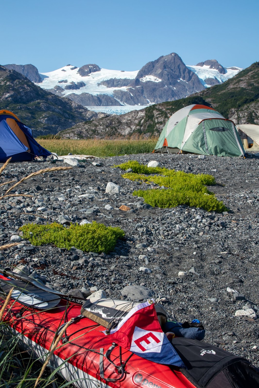
Good morning.
I awoke to this magnificent row of lenticular clouds. Each puff is a cloud that was formed over another peak and then blown over Nellie Juan Glacier.
The "Arctic Yosemite" made even more beautiful elongated clouds.
Breakfast. Lisa, Keri, Nancy, Joan and Beth
Another low tide launch.
So much beauty to explore.
After lunch the wind was picking up so Lisa, Beth, Nancy, Joan and I decided to just take the kayaks across the river behind camp and hike overland into the Nellie Juan glacier moraine lake.
It was very windy on the lake. Gone were the magical ice bergs and aquatic mammals I had seen the day before. We were concerned about the land mammals (bears) as we hiked through thigh high grass and through obvious bear beds and left over salmon feasts.
Locals would be astonished that this is a picture from Prince William Sound. Hot sun and no bugs.
Joan
Lisa
Beth
Nancy
Windy shore line.
Garden splendor.
Time to hike back to the boats.
Mountains in the background are behind Valdez 50 miles beyond our camp on the spit.
Blueberries
Always on the look-out for bears asleep in the grass.
The tide had come in while we were gone. Our boats pulled all the way up to the grass had sterns in the water when we got back to them.
We took advantage of the high water to paddle up to the falls behind our camp. The threat of bears had prevented us from hiking to the falls.
The creek bottom was lined with dead salmon and those spawning were inadvertently whacked with each paddle stroke.
End of another day of paddling and finally one with only a short carry to above the tide line.
Good night