To get from Anchorage to Nellie Juan Fiord, you first drive the Seward highway - one of the most beautiful highways in the world, traveling beneath the Chugach mountains along the Turnagain Arm of the Cook Inlet - to Portage. The air was smoggy with forest fire smoke and we had a tunnel to catch so I didn't get pictures of the drive. Last spring's 7.1 earthquake damaged the road and bridges. The highway was being repaired as we drove.
Anchorage upper left ↘ down the Turnagain → through the tunnel to Whittier - Epic Charters to Nellie Juan Fiord end of Dickerson Bay (SE of the "u" in Port Nellie Juan)
Seeing Portage Glacier again was a shock. When we visited in 1990, the ice bergs were up to the visitor center near where this picture was taken. Now only a large, ice-free, lake remains as the glacier has receded almost out of sight. (Older stock photo of Portage Glacier. There were no bergs when we drove by. It was smoky and we had a tunnel to catch).
Dave at Portage Glacier in 1990
Travel in Alaska comes with a few quirks like driving through the Anton Anderson Memorial Tunnel to get from Portage to Whittier - the longest (2.5) miles) highway tunnel in North America, and the first designed for -40 Fahrenheit temperatures and 150 mph winds. Since the tunnel is one lane, vehicles and trains take turns. The tunnel usually needs to be aired out in between trips with a jet turbine ventilation system. Last time I went through the tunnel, you had to unload your gear off the top of your vehicle and drive onto a rail road car for a trail trip through the tunnel. It has since been paved, allowing vehicles to travel directly over the railroad track at the same time thinking about the next big earthquake. (Not a place you would want to be.)
Waiting our turn to join the east bound vehicle traffic.
Mountains and glaciers everywhere you look in Prince William Sound
The wind and bouncing boat deck did not prevent me from taking pictures - they did prevent most of them from being in focus.
Dickerson Bay - Yosemite of the north. I wanted so much to be on that granite but there was a lot of trailess, willow crowded, bear country to navigate to get up there.
The falls behind our campsite. This stream was thick with spawning salmon.
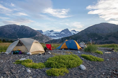
Where should we put up tents? Bears resting in the tall grass after feasting on salmon were a serious concern when it came to camp placement. (we carried bear spray and bear bangers on us at all times)
Bare rocks won out over soft grass.
It would be hard to get a more beautiful campsite. Since we were base camping and didn't have to fit everything into our kayaks, chairs were an added luxury.
View out my tent door.
I had been told to expect days of relentless rain with cold winds blowing down off the glacier. I brought my ski gear and boots with me. Fortunately I also threw in a light pair of pants and a tee.
Ten o'clock at night. The temperature was in the 70's. Bugs were not a bother. Bears had yet to be sighted.
It was hard to sleep with the light and all the beauty surrounding me. Ski gear did make a comfortable pillow and mattress padding for sleeping on rocks.


.jpg)


